
The flood and the city of Passau are two old acquaintances. Connected by a long common history one can hardly be imagined without the other. But why do so many floods hit the Three Rivers City in Bavaria? Passau, as its name suggests, is surrounded by three rivers: Inn, Danube and Ilz. This means that the potential is very high for the level of one of the rivers rises to such an extent that the water overflows its banks. Another reason for the frequent flooding in Passau is the geographical location of the city, which is unique in Lower Bavaria. surrounded by high steep slopes and the dense population on the banks, the water has no alternative in the case of continuous rain and rising water levels. The old town, which lies exactly between the Danube and the Inn, is usually the first to be hit. If the water level continues to rise, the Inn city and the inner city are also affected.
The last time this happened was during the great flood of the century . the case. After this year's flood, Passau gained nationwide attention beyond the borders of Bavaria. nationwide attention. And not only Passau was affected, numerous other towns and villages in Lower Bavaria were also flooded. All three rivers, the Danube, Inn and Ilz, overflowed their banks to such an extent that a disaster alarm had to be sounded. The old town of Passau resembled canals with brown water up to the first floor and the continuous rain continued. The record level of the Danube was measured on : 12.89 metres. The Inn reached a historic record level of 10.20 metres. Reporting level 4 and thus the highest reporting level was reached. The first reporting stage begins at a level of 7.0 meters, the highest reporting stage is reached at 8.5 meters. at 8.5 meters. At the latest then the disaster alarm is often unavoidable.
But what happens in Passau during a flood? Triggered by continuous rain over a period of days, the Inn backs up the Danube with its immense power and high flow velocity, so that the Danube overflows its banks and floods the city. banks and floods the city. The same happens with the Ilz, which in turn is dammed back by the Danube.
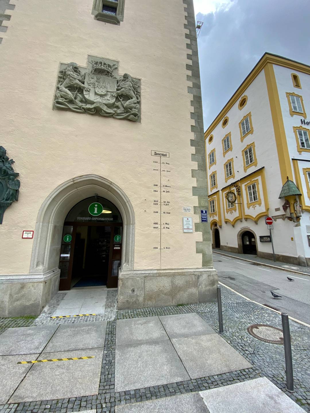
The town hall tower is a silent witness to the numerous floods in Passau. The markings still show today when and how high the level of the rivers was in the course of the the history of the city of Passau. The oldest record is from the year . The earliest record of high water in Passau is from . 12.54 metres is said to be the level of the level of the Danube measured at that time. However, this mark can no longer be seen on the town hall tower. The current water level can always be read at the Schanzl bridge in the centre of Passau.
To this day, the floods in Passau and their dangers cannot be completely averted. There are various flood protection projects that are currently being discussed. However, with the measures taken so far, such as the barrage in Austria, dams and improved methods for forecasting and an early warning system of the water management office, the Passau residents can breathe a sigh of relief. Everywhere in Lower Bavaria, precautions have been taken to ensure that this disaster does not happen again so quickly. In the future, measures should be taken more quickly to prevent such high damage to buildings, as was the case in .
approx. 10 m
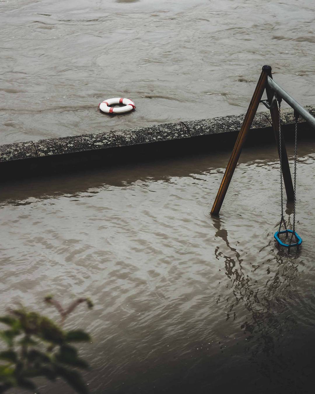
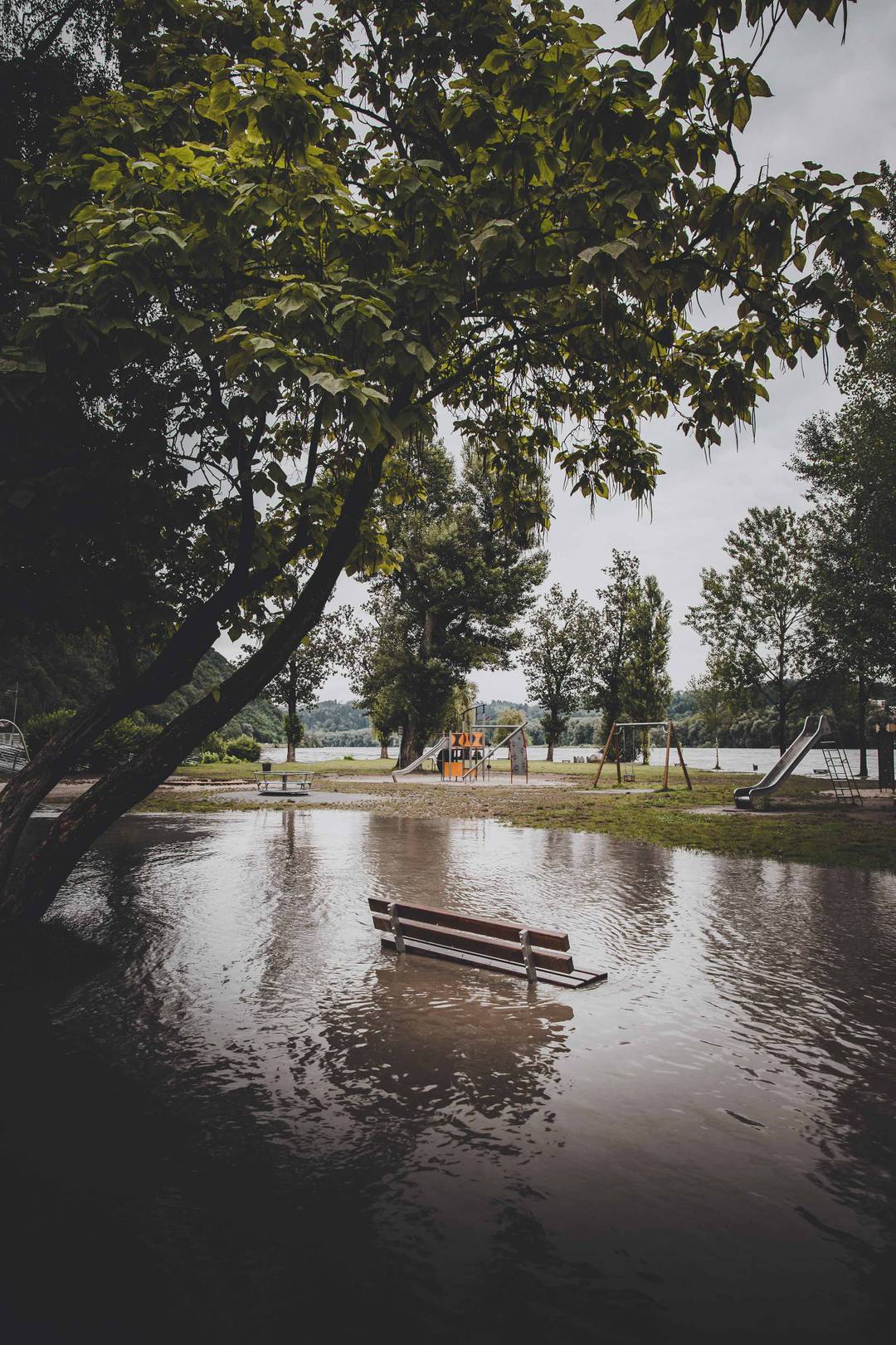
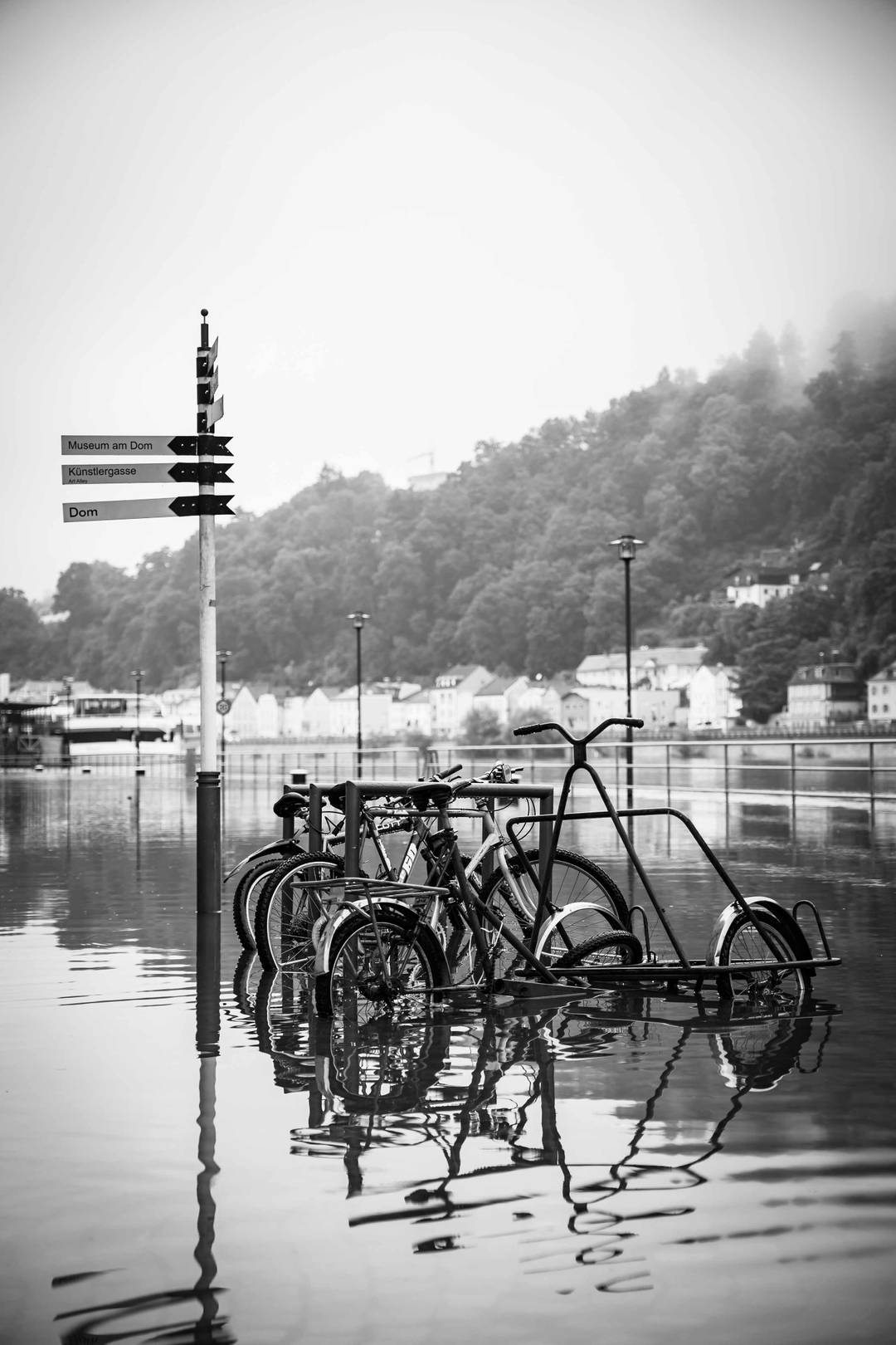
Due to a blocking high pressure area in north-eastern Europe, the low pressure area moved very slowly over the Alpine region at the beginning of June 2024. In short, this meant persistent rain showers in Bavaria and Baden-Württemberg and thus rising water levels.
Initial estimates predicted a maximum water level of 7.80 meters (reporting level 3) for the Danube in Passau. What the experts had not expected, however, was the unexpectedly heavy rainfall and the enormous rise in the Inn. In the early afternoon of June 4, both the Inn and the Danube peaked at 7 meters (reporting level 3) and 10 meters (reporting level 4) respectively, causing the city of Passau to declare a state of emergency.
As a result of the flooding, several streets were closed, the old town could only be accessed by car by residents and daycare centers and schools had to close. In addition, the town hall square and the Inn promenade were completely flooded.
approx. 8.24 m
In western and central Europe, low Bernd caused numerous floods in July 2021. Affected Belgium, the Netherlands, Austria and Switzerland, as well as Germany. Here, with a focus on 14 July, up to 150 litres of rain fell locally within 24 hours. According to the German weather service, this only happens once every 100, perhaps even once every 1,000 years. In particular North Rhine-Westphalia and Rhineland-Palatinate were particularly affected by severe flooding. At least 180 people died, including five firefighters. The district of Ahrweiler was was hit particularly hard: Houses collapsed, bridges were swept away, and some residents could not be rescued from the floods in time.
A few days later, on , the effects
of the high precipitation also became apparent in Passau. Both on the Danube and on the Inn, the water overflowed the banks.
Despite the initially tense situation, a maximum level of 8.24 metres was reached, which was only
level 3.
approx. 12.89 m
The flood is considered the second highest the city of Passau has ever experienced. A water level of 12.89 metres on the evening of June caused damage of over 100 million euros. The rain at the end of May and beginning of June fell on ground that was already wet and could no longer absorb the water masses. All rivers in the affected area overflowed and carried the water into the Danube or the Inn, which also resulted in a historic level of the Inn (10.20 metres). Passau was under disaster alert for 9 days, in the old town electricity and water supply failed. Only on the city lifted the disaster alert.
The 2013 flood is considered the second worst flood disaster in the history of the city of Passau. The problem this time was not only the Danube but especially the Inn. The Inn already carried twice as much water as the Danube on and dammed it back at the confluence of the two rivers. When the water rose even faster than expected, the city of Passau called for a disaster alert on Sunday, and asked for the help of the German Armed Forces. Already in the evening of that day, the power supply failed in parts of the city. On the following day, the Passau public utility company was also forced to cut off the city's water supply. One day later, decentralized distribution points were set up for the citizens and the hospital in Passau continued to be supplied by tankers, so that an evacuation could be averted. could be averted. The maximum level was 12.89 meters and was measured in the evening of the The Inn also reached a historic high of 10.20 metres on this evening.
The flood caused countless damages, from basements filling up to leaking tanks that caused a layer of oil all over the old town. The total damage was estimated at approx. 100 million euros. The Passau retail trade suffered the most, since many shops had no chance to clear their shops and therefore not only the furniture but also all goods were destroyed. Particularly badly damaged was the theatre, which had to close down for the rest of the season, as well as the historic ScharfrichterHaus.
In the night of , the level of the Inn began to fall, which also led to a reduction in the Danube level. From this point on, the flood waters began to recede , revealing the masses of mud it had left behind in the entire city centre. Already on the , more than 1200 helpers from the fire brigade, the THW, the Bundeswehr, the police, the BRK and the DLRG were in action in Passau. there were were over 3000. A large part of it were also the students of the University of Passau, who at first tried to save the university but later also helped in the whole city and earned a great respect in the population, which would not have expected it. The disaster alert remained in effect for nine days, until .
approx. 10.81 m
Only a few years earlier, Passau had been hit by a severe flood. The level of the Danube showed a peak of 10.81 metres at midday on Not only Bavarian areas were affected by the flood, but also large parts of Saxony. The floods were triggered by very heavy rainfall lasting several days at the beginning of August.
approx. 11.17 m
At the World Cup, the constant rain helped the German national team to the "Miracle of Bern", but it was this persistent rainfall that led to the worst natural disaster in Bavaria of the 20th century. Of course, Passau was, as with every heavy flood in the region, was affected with a maximum water level of 12.20 metres. This is the fifth highest water level in the history of the city. A total of twelve people during the floods in ,seven of them from Lower Bavaria, lost their lives.
approx. 10.47 m
The flood of reached a maximum level of about 10.47 meters. This was not a very severe flood for the city of Passau, , which is why there are few records of it.
approx. 11,17 m
The level reached by the Danube in Passau during the flood of was about 11.17 meters. Professor of Geography at the University of Vienna, Dr. Albrecht Penck, gave as the reason for the flood that year, that the ten preceding years had already been very rainy, so that such a flood was only to be expected. Photographs show how the citizens of Passau citizens paddle on rafts through the Ilz breakthrough.
approx. 11,30 m
The flood in was caused by persistent thaw and simultaneous continuous rain. The water level in Passau Passau broke the 11 meter mark on and reached a peak of 11.3 metres. Besides Passau, Vienna was particularly affected. In capital of Austria, this flood was the impetus for the subsequent "Danube regulation".
approx. 11,71 m
The name "Allerheiligengieß" (All Saints' Pour) was given to this flood disaster due to its proximity to the the catholic holiday "All Saints' Day". The highest water level in Passau this year was Passau was 11.71 meters. The reason for the increased flooding from can be traced back to the eruption of the volcano "Laki" in Iceland in , which changed the climate of the northern hemisphere permanently.
approx. 12.04 m
An abrupt melting of the winter snow together with heavy rainfall caused a severe flood in Passau with a water level of over 12 metres. The city's worst flood was less than a hundred years ago.
approx. 13,20 m
In the summer of , heavy over-rainfall led to one of the greatest flood disasters in the whole of Central Europe around the Danube. The city of Passau experienced the highest water level ever recorded, about 13.2 meters,
approx. 12.54 m
A winter with heavy frost and snowfall was followed by a severe flood with a documented water level of about 12.54 meters, the third highest ever recorded. This is also the only flood not recorded on the Town Hall tower, as it occurred almost 1000 years ago and records of the flood are poor.
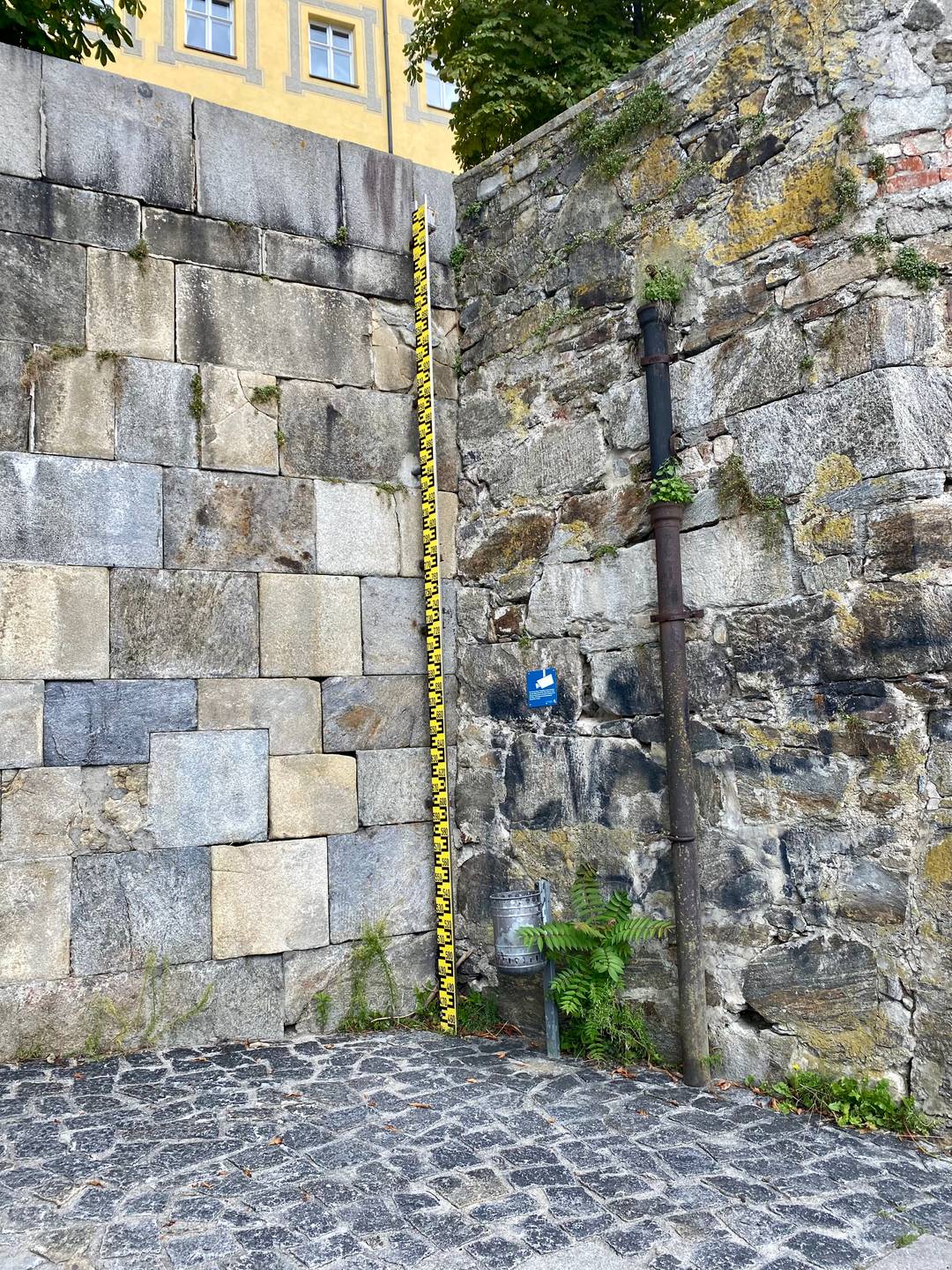
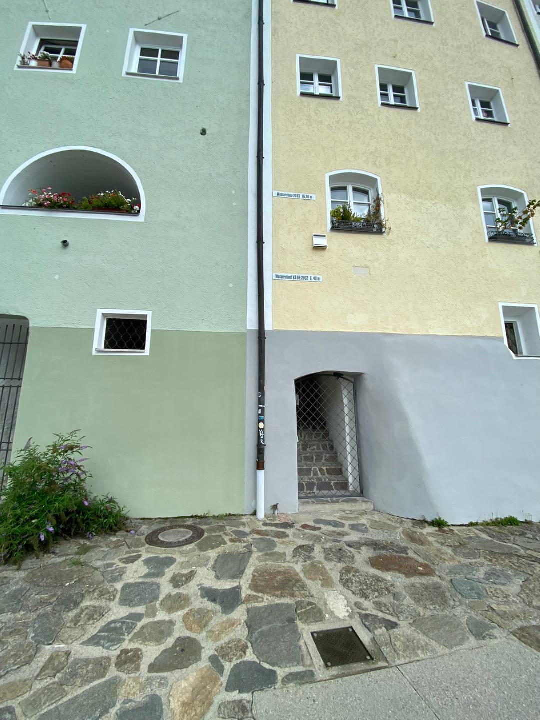
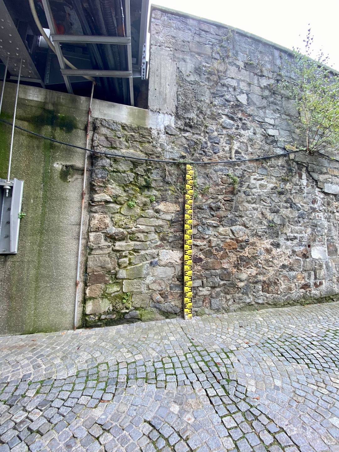
If you look closely, you will find them everywhere in the city of Passau: water level markers. These markings on buildings show to where a certain historical high water level in Passau has risen. If you would like to see for yourself a picture of past floods in Passau, you can find a list of prominent level marks here.

We have forgotten a level marker? Feel free to send us a short message (contact).
Floods can quickly turn a quietly flowing river into a raging torrent. Meanwhile, there are some apps that warn of such disasters. Here is a list of the most important Warning apps.
The warning app NINA obtains its information from the Federal Warning System (MoWaS) and warns users of dangerous weather, major fires or the spread of hazardous substances. The warning takes place via push messages and personalized warning tones. The app requires a data connection, so the smartphone must be connected either via a mobile network or WLAN. It can be defined for which locations (cities, municipalities, counties) messages should be received. On the other hand, the location function of the smartphone can also be used to provide the most accurate, up-to-date messages. NINA also provides tips on what to do in the event of an emergency, such as in the case of flood or fire.
App NINA: https://www.bbk.bund.de/DE/Warnung-Vorsorge/Warn-App-NINA/warn-app-nina_node.html
The KATWARN app provides official warnings and recommendations for action from authorized
authorities and organizations for security. These are forwarded to the user by the app.
KATWARN also works on older mobile phones on which the app cannot be installed. For this
simply send an SMS with
KATWARN POSTCODE
(POSTCODE = your postal code) to the number 0163 7558842, in order to receive warnings as SMS directly
to your mobile phone. Please note that the alerts are sent with a vibration effect, but
the volume of the alert depends on the volume of the device. If the mobile phone is set to silent,
no alarm sound can be heard.
App KATWARN: https://www.katwarn.de/WarnWetter
The WarnWetter app is operated by the German Weather Service (DWD) and shows the current weather situation in Germany in detail. and sends push notifications if storms, precipitation, thunderstorms, icy conditions are reported. The app's data comes from the German Meteorological Service. In the app there are no advertisements for users.
App Warning Weather: https://www.dwd.de/DE/leistungen/warnwetterapp/warnwetterapp.html
ACHTUNG.PASSAU! is the information management system of the city of Passau. In case of an emergency, for example rising flood levels, the citizens of Passau are informed via this system. The warning system is composed of:


Several times a day you will find new pictures or videos of the panorama taken from the Veste Oberhaus.

View Feratel webcam and agree to the privacy policy.
Webcam is loading.
 Who now thinks you can buy Hochwasser from Passau - really? But there is a fine liqueur from Passau called Hochwasser.
With a purchase you also support a non-profit Passau institution. And it definitely tastes much better than Hochwasser.
Who now thinks you can buy Hochwasser from Passau - really? But there is a fine liqueur from Passau called Hochwasser.
With a purchase you also support a non-profit Passau institution. And it definitely tastes much better than Hochwasser.
More at hoch-wasser.de
Passau and floods somehow belong together. Surrounded by the three rivers Danube, Inn and Ilz, flooding in Passau is no exception. For those affected and interested, we have bundled the most important information on this website:
Hochwasser-Passau.de is not an official site of the city of Passau, but of Passau citizens. We have been living and working in Passau for years and are thus regularly confronted with more or less flooding. Flooding is therefore not a television image for us, but something we have often experienced ourselves. With our website we want to offer everyone easy access to all important information about the current flood situation in Passau - tourists as well as residents.
Suggestions for improvement or pictures incl. rights of use are welcome (contact).